RDP Prizreni
- Home
- >
- Regional Directories
- >
- RDP Prizreni
Regional Police Directorate - Prizren
The responsibility area of this Directorate has the surface of 1.706 km2 with a population of about 277.007 residents with mixed ethnicity of Albanians, Turkish, Bosnian and Serbian: RAE community, Gorans, etc. This population mass is distributed into four municipalities that cover a total of 152 villages. Within this RPD – Prizren are:
I. POLICE STATIONS:
o Prizren,
o Suharekë,
o Dragash and
o Mamushë.
II. POLICE SUB-STATIONS
o Sreskë,
o Zhur,
o Mushtisht and
o Krushevë.
III. Regional Traffic Unit in Prizren
IV. A brief history about the strand and progress of Kosovo Police in the Prizreni region
o On 6 September 1999, the OSCE mission in Kosovo, in accordance with the EU resolution 1244, has established the Police School and has begun with trainings of candidates for KPS members.
o In the mid of November 1999, 15 new members of KPS, after graduating in the Police School in Vushtrri, started their work on patrolling in the Prizren Region, alongside and assisted by UNMIK police, who had taken over the training of these police officers in the field.
o After the independence of the police stations and sub-stations in this region, and after taking the responsibilities for the public order and safety, on 23.06.2005 was done the transferring of competencies to the regional command of Police in Prizren and since then it’s been working in helping citizens, mainly based on their forces.
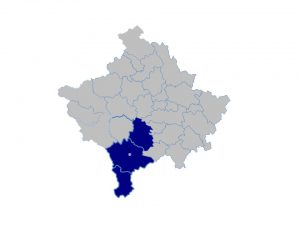
RESPONSIBILITY AREA PRIZREN
PRIZREN
Prizren is an ancient historic city that lies on the Lumbardhi river costs, scenic hillsides of Sharri Mountains. The archaeological records prove that Prizreni is one of the oldest cities of the Southeast Europe and wider. Being a subject of major social movements during the certain periods, Prizreni has experienced ups and downs of economic, social and cultural developments, undergoing transformations of naming as well. The historical records shows that the greatest flourishing of development in this city was during the XIV and XIX century, when it was known as a strong trade center, nurseries of craftsmanship, culture and art, and this is proved by the presence of more than 65 historical estate monuments and over 600 other mobile monuments under the state protection. Not coincidentally Prizreni is called museum city.
Geographical position
The municipality of Prizren lies in southwestern Kosovo. It borders with Albania to the west, with FYROM in southeast, with Gjakova municipality in the northwest, with Rahovec in north, Theranda northeast, Dragash in south and Strpce in the east, and consists of 73 cadastral municipalities. Surface – 608 km2 (5.58% of the territory of Kosovo) – altitude – is 412 up to 500m, whereas the mountainous altitude (Sharri peaks) exceeds 2000 m, Climate – the climate is that of Mediterranean climate. Prizren has 29,289 ha private-land, – 34,697 ha social land, and – 3,300 ha under the irrigation system.
Population
The population according to the latest census of 2011 and subsequent evaluations made by the Statistical Agency of Kosovo, the municipality of Prizren has around 177.781 residents in 31.419 families.
Tourism
Regional favorable geographic position and rich natural basis, various cultural-historical objects, as well as delighted folklore, are the main bases for the development of tourism in this city. This has made Prizren to be the most visited touristic city in Kosovo. Prizren has the potential for a sustainable development of transit, mountainous, winter and weekend tourism. These types of tourism are present and they are good resources of incomes for the businesses. Winter mountain tourism in Prizren is surrounded by mountains on three sides. Sharri Mountains have the altitude up to 2750 m. There are 16 mountain lakes. A great part of this area is under protection in order to develop tourism. The Kotornik and Pashtrik mountains present a very great natural potential for the development of mountain tourism. In Sharri mountains are hundred meters of skiing trails which at the moment are not used properly, but they have a great potential for the development of winter tourism.
Places and objects of special importance:
a) Complex of Albanian League of Prizren,
b) Hammam of Gazi Mehmet Pasha (XVI century),
c) Catholic church (1870),
d) Hammam of Gazi Mehmet Pasha gallery,
e) Our Lady of Perpetual Succor Cathedral,
f) Sinan Pasha mosque (XVII century),
g) Shën Premta church,
h) Emin Pasha mosque,
i) Tarikati Halveti tekke
j) Stone bridge,
k) Lumbardhi river
l) Prizren market (Namazgjaja),
m) Oak in Marash,
n) Fountain,
o) Tower clock.
Culture – For preservation, cultivation and presentation of the material and spiritual culture heritage values in Prizren city are:
Cultural House with library for children and adults
Institute for Protection of Cultural Monuments, within whose are: Archaeological Museum,
Hydro-electro-economy Museum,
Memorial Complex of the Albanian League of Prizren (with the historical museum, ethnographic section, gallery of arts and library),
Regional Historical Archive
Cinema “Lumëbardhi” with the summer garden for projection of movies in the open sky,
Dozens of amateur CAA,
Literary club,
Association of painters and NGOs involved in the cultural field.
Infrastructure
The traffic network of the Prizren municipality is about 550 km and consists of regional and local highways. Prizren and villages around it are supplied with drinking water system from 4 main sources and from the lake Lumebardhi through the filtration system. The overall surface covered with water supply system is about 13.5 km2 and the average amount of the water consumed by the residents is 150 liters in 24 hours.
AREA OF RESPONSIBILITY SUHAREKË
SUHAREKA
Geographical position
Suhareka municipality is located in the southern part of Kosovo. This municipality has an area of 361 km² and comprises of 43 villages. It borders with the municipality of Prizren, Rahovec, Malishevë, Lipjan, Shtime, Ferizaj and Strpce. Suhareka municipality is surrounded by high mountains, in the north-west with Pagarusha and Temeqina mountains with an altitude of 796 to 828 m, to the north with Carraleva from 922 up to 1,048 m, to the east with the mountains of Jezerc 1.677 m (Kryet e Ahishtes) and south-east with Sharri Mountains 2.092 m (Dera e Pashës) whereas in west with the plain (lowland) of Prizren. The average altitude in the municipality is 455 m, while the Suhareka city is in the average altitude of 400m. The surface of this municipality is 361 km2 that covers 3.3% of the Kosovo territory. From the municipality surface, including 36.099 ha (or 361 km2) 15.074 of them or 41.7% are covered with forests, 19.373 or 53.7% are agricultural land and 1.652 or 4.6% others. Through this municipality, with a good geographical position pass very important roads that connect the capital Prishtina with the regional center of Prizren and Albania.
Population
In the Suhareka municipality live about 59.722 residents. A special feature of the residents in this municipality is that it has a very young population, a very important factor for the future economic and social development. Gender structure of the population is almost equal 50 (F) and 50 (M)
Ethnical structure- Suhareka Municipality was mainly inhabited by the Albanian population while the minorities have had very low participation, which has repeatedly gone decreasing. It is estimated that about 95% of population are Albanians and 4.2% other communities. The total number of families is thought to be about 11, 667 (an average family has 7.5 members).
Agriculture – The overall surface of the ground in Suhareka municipality is 36,099 ha. The surface of 19,373 ha (53.7%) is fertile agricultural land; 1652 ha (5%) is badland or wasteland; and 15,074 ha (42%) are forests. From the overall surface of 19,373 ha, agricultural land occupies an area of 12666 ha. This ground is planted with agricultural cultures such as; cornfields, vineyards, vegetables and fruit trees. Meadows occupy a surface of 2250 h, pastures 2875 ha and 1582 wasteland.
Livestock – The surface of meadows, suitable field for pastures and ongoing interest of farmers for livestock and poultry are very important potentials for the economic development and alleviation of social problems in villages.
Forestry – The territory of this municipality has a forestry surface of 15,074 ha. This surface consist of about 41.7% of the overall surface, from which 8685 ha are in social ownership (or 57.6%) as well as in private ownership 6389 ha (or 42.4%)
Tourism
In Suhareka municipality, the hostelry and tourism has never had any special importance in the overall economic development. Suhareka municipality has quite suitable and interesting areas for the development of tourism, located in the complex of Sharri Mountain, which lies in the northeast and southeast of Mushtisht, as well as in the mountain area of Carraleva. Natural beauties, rich herbal vegetation, aqueous and sea level altitude of 1500 m. 2400 m, Alpine Mediterranean climate arouse the curiosity of visitors during the summer and winter.
Interesting places to visit
Pasha Tower in Mushtisht, the House of Ramë Bllaca, Bllace, House of Jonuz Tafolli in Qadrak. All individual or collective memorials of martyrs, memorial of civilian victims of war massacre in the Berisha neighborhood in Suhareka, mills of Breshancit, milling of Dragaqina, milling of Budakova, milling of Semetishti, Mountain of Sharri, stone of Dellocit , Buqalla in Reqan.
Culture-Cultural archeological heritages – in this municipality are in total 8 cultural institutions, 3 cultural houses, one youth center, 3 libraries and 1 public archive.
Suhareka municipality has many archeological locations registered, proven or supposed. The material archeological culture of Hisari, Rashtan, Studenqan, Kasterci, Peqan, Bllaca, Dubiqak, Shirokë etc, show convincingly the continuity of the life starting from Paleolit time until nowadays. The archeological pool in Suhareka is of a special importance for the archeology and Balkan history in general and the Albanian one especially. This is proven by the archeological excavations of 60, 70s and stratigraphic verified excavations Hisari 2003 and Hisari 2004.
Infrastructure
In this municipality so far were asphalted 110 km roads.
Civil society – There are various NGOs operating in the Suhareka municipality and which deals with various activities.
RESPONSIBILITY AREA DRAGASH
DRAGASH
Geographic area
Dragash municipality is located on the southern part of Kosovo, in the border triangle of Kosovo, Albania and Macedonia, with an altitude of 1500 m, which represents indisputable priority for the development of winter, mountain tourism and farming. Dragash municipality has a territory of 435 km/2, and geographically consists of two ethnic areas – Opoja inhabited with Albanians (extended on 18 villages) and Gora area inhabited with Bosnian-Gorani (also extended in 18 villages), that in general are 36 villages. In the surface structure of this municipality, 62% of the ground is used for pastures, 16% mountains, 13% meadows and 9% fields.
Population
In the Dragash municipality, the number of population is about 33.997 inhabitants, with an average annual increase of 1,7%. The ethnic structure based on the official records used and based from the UNMIK and OSCE, results that it has to be 58,7% Albanians and 41,3% Bosnian-Gorani.
Interesting places to visit
The whole territory of the Dragash municipality is interesting to be visited, thanks to the rare natural beauties, especially hilly-mountain parts and border belt. Thanks to these features, local mountains in general may have the epithet of a national park and may be attractive for winter and summer tourists, especially parts in the villages: Restelicë, Brod, Radeshë, Zaplluxhe, Liqeni i Breznes, Shpella e Zgatari, Namazgjahu, HC Dikancë etc.
Tourism
For the Dragash municipality, the winter and summer tourism presents a still unused perspective, since there are ideal preconditions for this and this is enabled by the natural features – rare flora and fauna and attractive mountain terrains. In this context, the recreational-touristic Center in Brod is functioning successfully. Argjena, where already are being organized various official and private meetings, while the interest for extending the similar centers and in other attractive mountain environments is great.
Culture – In Dragash functions the Cultural House and 3 other houses in the terrain (Bresane, Bellobrad and Krusheve), there are also some libraries that function with the main library in Dragash and some others in school institutions, which need refreshment in library fund.
Infrastructure
After the post-war, in the whole territory of this municipality has been asphalted near 120 km road, reciprocally in the two zones Opojë and Gora. The issue of drinkable water has been solved by most of municipality locations through the water suppliers build with the engagement of their own funds, voluntary work, or various donor projects, so it is intended that currently the water supply network is near 200 km. But Dragash as a municipality center still has problems with the qualitative drinking water, since it is being filtered by the older filtration system.
Civil society – Currently the activities in the Dragash municipality can be distinguished only with NGos such as: Mështekna, Memleqët, Dora e Ndihmës, Flaka, Sara, Dora e Shpresës, Qendra Rinore (DYC) etc.
RESPONSIBILITY AREA
MAMUSHA
Mamusha was established by the Administrative Order 2005/11, dated on 27 September 2005.
Geographic position
The territory of Mamusha consists of 12.4 km and is bordered with the municipalities of Rahovec, Suhareke and Prizren.
Population
Mamusha has about 5.507 inhabitants with ethnic structure of: Turkish, Albanian and Rome.
Tourism and interesting places to visit
In Mamusha municipality exist various characteristic clothing and festival of tomatoes. And it is worth to visit the Clock Tower and various natural attractions.
Public – Administrative Services
Culture – The cultural life in Mamushë is covered by a cultural house which is in function.
Infrastructure
While the infrastructure here is somehow satisfactory. There are about 2.4 km asphalt and about 7 km sewage system. Mamusha also has 7 km of water supply system and is supplied by the underground sources. The system of fix telephony is in function in the whole territory of Mamusha.
Civil society: Currently in Mamusha are in function three non-governmental organizations, such as A.k Alperenler and Businessman of Mamusha.
Biography

Drejtor i Përgjithshëm i Policisë së Republikës së Kosovës
z. Gazmend HOXHA

https://www.facebook.com/KosovoPolice
General Statistics: 2024-03-18
0
Accidents with fatalities
15
Accidents with injuries
26
Accidents without injuries
1768
Traffic tickets imposed
20
Arrests
13
Detention